In this episode of our continuing series on crime in Detroit, we’re going to use a new dataset from the Detroit Open Data Portal to view the data through a slightly different lens. Once again, I’ll employ two of my favorite analysis and visualization tools – Exploratory and Carto.
First, a minor digression; none of these posts are intended to be mean-spirited or seen as attacking the Motor City. I have lived in the city for the last 25 years, and also worked in Detroit for the last 15, and love many aspects of the city. My sincere hope is that the Covid-19 policies coming from Lansing will not fully derail so many of the good things happening in the D over the last 5+ years. However, no one living in the city can be oblivious to the crime around us, so I will continue to feature crime as a topic, hopefully offset by some more positive stories that reflect the good going on in the D.
OK, back to our topic for this blog, where we’ll use a dataset that provides boundaries for Detroit Police scout cars. There are 131 of these defined areas rolling up to the precinct level. My hope is that this will provide us with a more granular look at the frequent trouble spots, as categorized by some of the most serious crime charges.
To begin, we’ll have a look at the general patterns by Scout Car Area using Exploratory. I’ve selected four crime types based on the ‘offense description’ data from the portal. Each of these four crimes have a major impact on quality of life in the D:
- Aggravated/Felonious Assault
- Motor Vehicle Theft
- Murder/Non-Negligent Manslaughter (Voluntary)
- Robbery
There are certainly many others we could have chosen, but we’ll save those for a later date. Using an Exploratory table, here’s a look at the Top 20 (of 131) based on the aggregate volume of these four crimes.
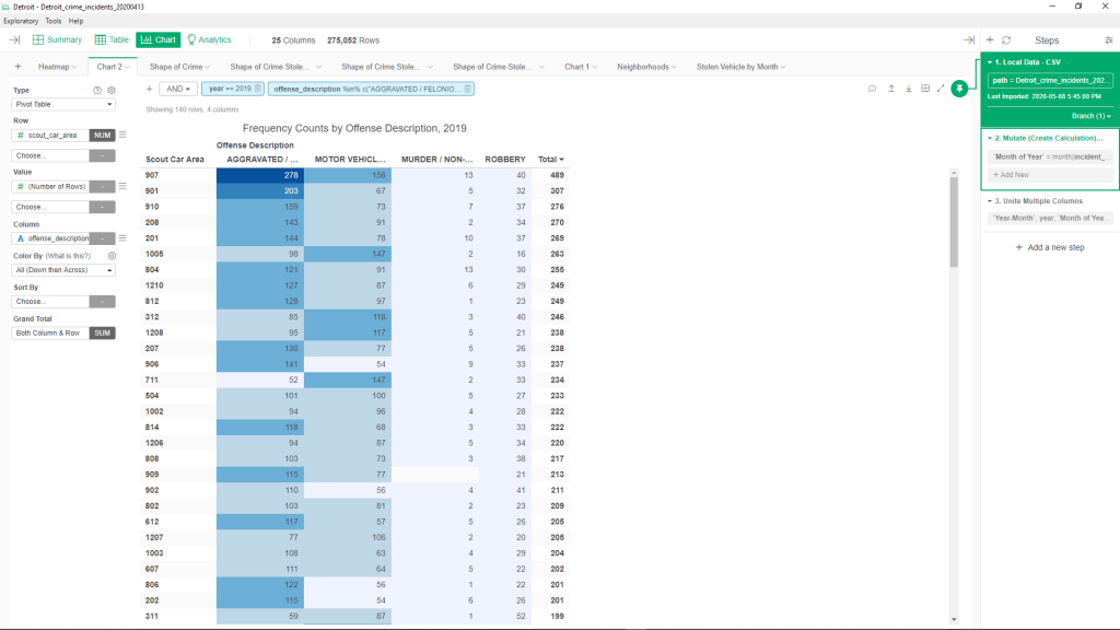
Interesting patterns here – the Top 3 are all in the 9th Precinct (907, 901, 910), joined by 906 and 909 further down the list. So our initial hypothesis is that the 9th Precinct, on Detroit’s Northeast side, is a source of considerable major crime. We also have four areas from the 8th Precinct (804, 812, 814, 808), and three more from the 2nd Precinct (208, 201, 207). The 8th is on the far Northwest side, while the 2nd adjoins it on the West side. Between those three precincts, we have covered 60% of the Top 20 hotspots for these four categories of crime.
If we examine the numbers a bit further, it becomes clear that 907 is a real trouble spot – first by a long ways on Aggravated Assault, first by a narrower margin for vehicle thefts, and tied for first in murder and robbery, at least within the Top 20 areas. These numbers should stand out when we examine some maps later in the story. Area 901 is high on assaults, but somewhat lower in the other categories. There are other patterns that stand out – areas 1005, 312, 1208, and 711 are all much higher on vehicle theft than they are on assaults. It will be interesting to see their geographic boundaries so we might better understand the causes for this counter-pattern.
To really emphasize just how prolific the 907 area is, take a look at this stacked bar chart:
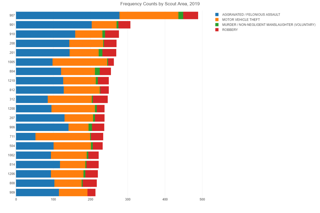
Only a handful of scout car areas have even 50% of the crimes of the 907; given that these areas are all sized roughly the same, this gives us a clue that 907 is a highly dangerous area.
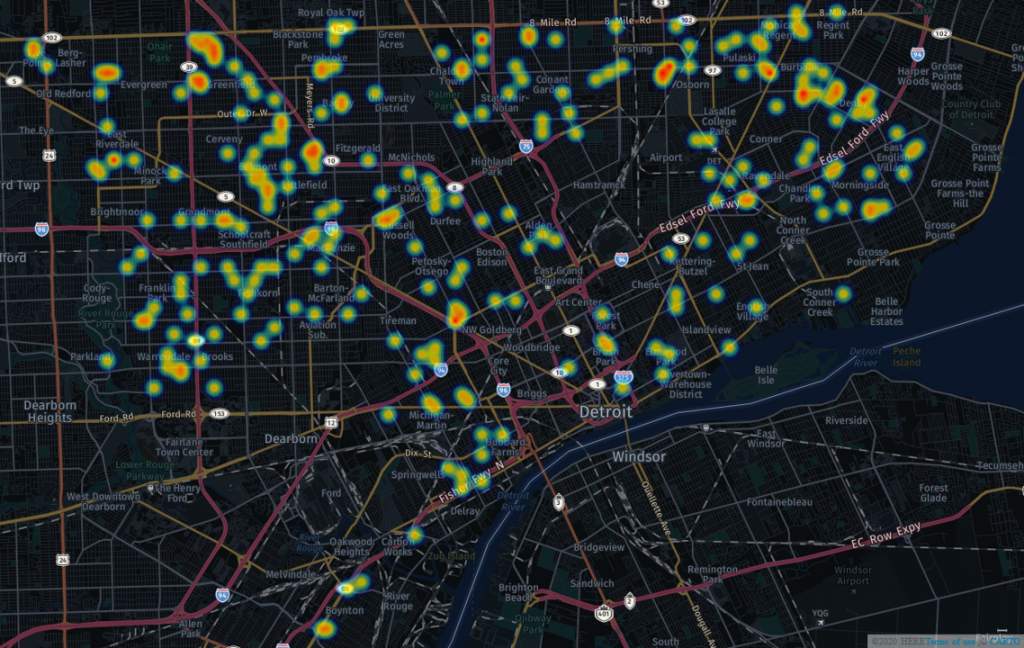
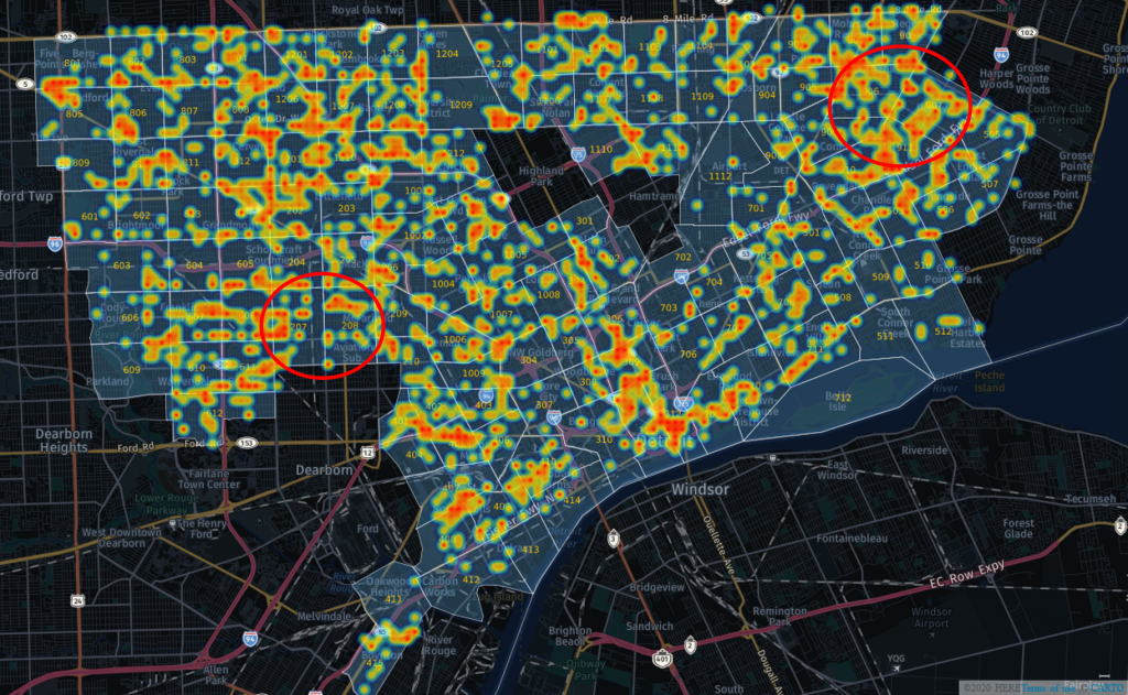
Now let’s move on to some maps, where we’ll examine each of the four categories, with an overlay of the scout car areas. We’ll start with the most serious (albeit less frequent) crime of the four – murder. Here’s the map without the overlay:
And now, with the scout car area overlay, and some of the murder hotspots highlighted:
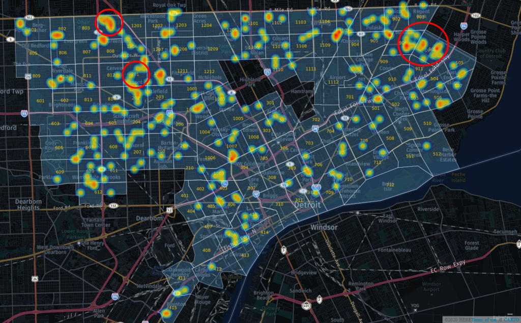
In the upper right of the map is our notorious 907 and the adjacent 906, together responsible for 22 (of 314 total) of the city’s murder charges in 2019. That small areas represents 7% of all murder charges in the city for 2019! Gang activity is certainly one of the causes for this elevated level of mayhem, as well as (or including) related drug activity and the turf wars that often ensue.
On the west side of the city, we first encounter area 201, with it’s own 10 murder charges, and then area 804 near the northern border (8 Mile Road) of the city, tied with 907 at 13 murder charges for the year. On a positive note, we can see a number of areas with no murders at all for the year, although the majority have one or more, dotting the map in not quite random fashion.
Our next look will be at robbery patterns, to see if the same areas continue to predominate, or if we will see different hotspots on the map. On a technical note, we need to adjust the size of the markers, since robbery is more prevalent than murder. Otherwise, our map would be overwhelmed with heatmap colors, and we would lose the ability to identify the true hotspots. Let’s have a look at the whole city first, with two of the hottest areas highlighted:
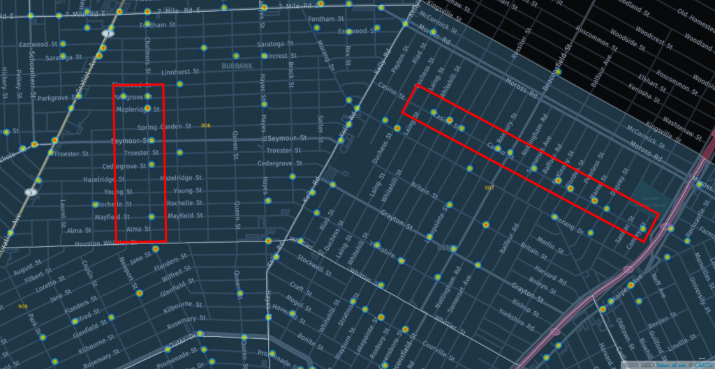
Once again, we see the 906/907 areas in the Northeast, and I have also highlighted the 207/208 areas on the west side. With robbery, we have higher volumes that allow us to dive down to the street level to get a better picture. Note that there are several types of robbery charges in the database; I’m using just the simple definition here. Now let’s zoom in to the 906/907 area to see if there are local hotspots behind the numbers. One street in each area seems to be over-represented in the data – Casino Street in the 907, and Chalmers St. in the 906. Notice how many blocks have no activity, a positive sign. We don’t know if these are empty blocks, or if the hotspots just present more opportunities.
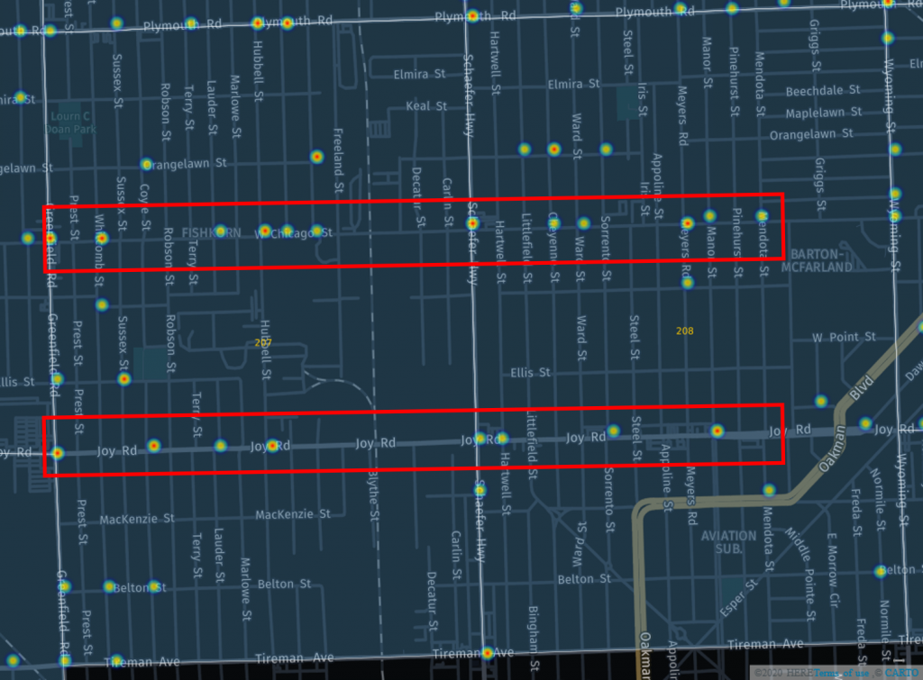
Moving on to the 207/208 areas, it is quickly apparent that Chicago St. is the locus for robbery activity for both areas, with Joy Rd. not too far behind. Plymouth also has significant activity. Given that these are the three primary east-west routes in the area, it isn’t surprising that they capture much of the robbery volume.
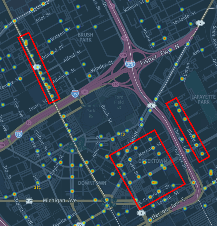
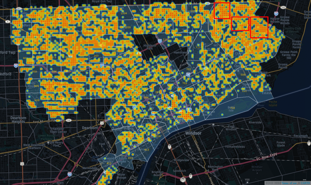
Let’s move on to stolen vehicle activity, where our focus will be on three areas we haven’t yet seen.
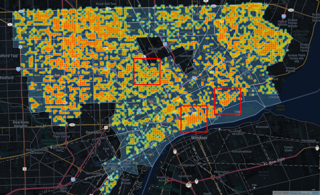
These three areas are 312 (downtown), 711 (lower east side), and 1005 (northwest of downtown). Vehicle thefts are a very different sort of crime compared to robbery, assault, or murder, in that they usually don’t involve direct contact with another individual. Carjacking is a different story, but those crimes are not included in this category. So now we have areas that tend to have lower activity in the other categories, but provide ample opportunity for vehicle thefts, based on opportunity, location, and ease of access.
Let’s look at the core downtown area included in 312, with a little extension into the neighboring 709 area just east of downtown. We can identify three areas with high levels of activity, starting with the entertainment district centered around Greektown. This is an area with a surplus of restaurants, bars, and clubs, and thus draws many visitors from the city and suburbs. We also see a stretch along Rivard just east of Greektown, across the 375 freeway. While this is a more residential neighborhood, there is plenty of street parking that may be used during events or on busy evenings. Finally, we see a stretch of Woodward north of the I-75 freeway, with plenty of activity. Woodward is a major north-south route, so this may simply reflect the level of opportunity.
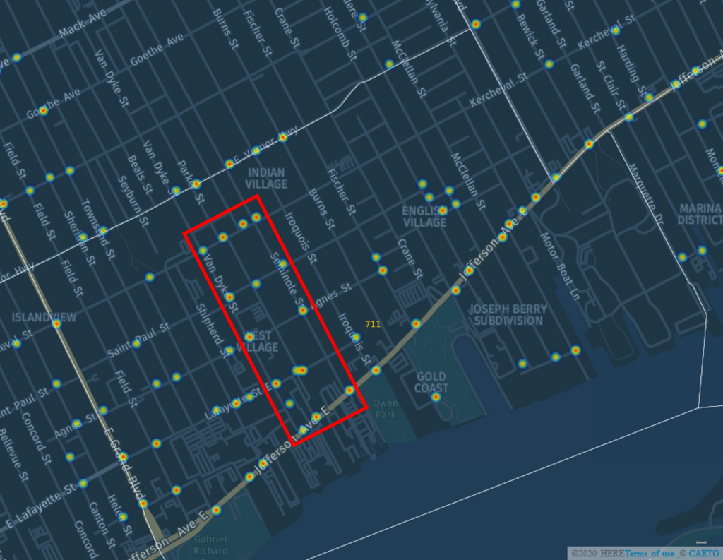
Our next view is from the 711 scout car area. We’ve now moved further east along the Jefferson corridor, and landed in The Villages, generally a fairly affluent, low crime rate area – except when it comes to vehicle thefts. Hotspots on Lafayette and Kercheval, as well as Van Dyke and Jefferson, make this area index far higher than it does for crimes such as robbery or assault. As we noted in a prior blog on vehicle theft, Detroit’s geography lends itself to an easy in, easy out ability to steal a vehicle and depart from the area with minimal delay, regardless of the affluence of a neighborhood.
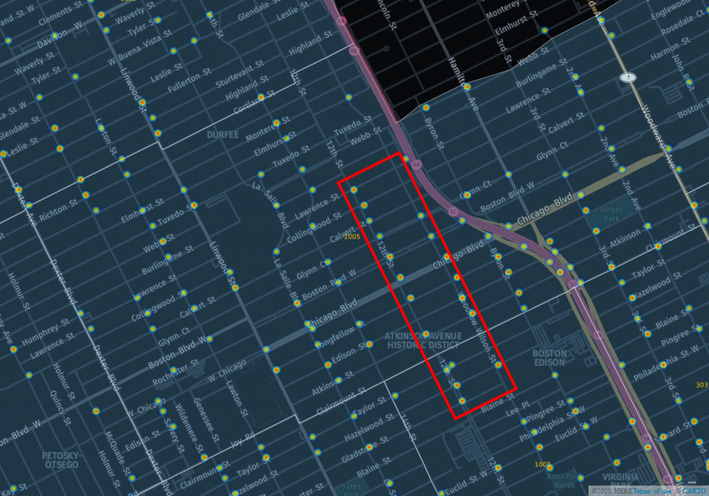
The third and final scout car area (1005, stretching into 1008) in our vehicle theft focus is located on the northwest side of the city, just west of the Lodge freeway (M-10). 12th Street appears to be the epicenter for this crime, with Woodrow Wilson close behind. Easy access to the Lodge may make this an attractive area for car thieves.
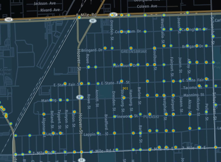
Our fourth and final visual analysis takes a look at Aggravated / Felonious Assault, a serious offense that involves violence with some sort of weapon and an intent to do harm. While there are many areas we could see elevated rates for this offense, we’re returning to the northeast side, with areas 910 & 907 now joined by scout car area 901. These three areas have exceptionally high incidences of aggravated assault; again, one wonders if this is a by-product of local gang and drug turf wars.
Let’s start with the 901, an area on Detroit’s east side running north to the city border of 8 Mile Road. You’ll notice here I have not outlined an area within the 901, since the assault charges seem almost random across the neighborhood. This would seem to make policing the area quite difficult, as there are not just a couple streets that may represent gang borders. In the 901, assault appears to be an all too common occurrence without a real pattern.
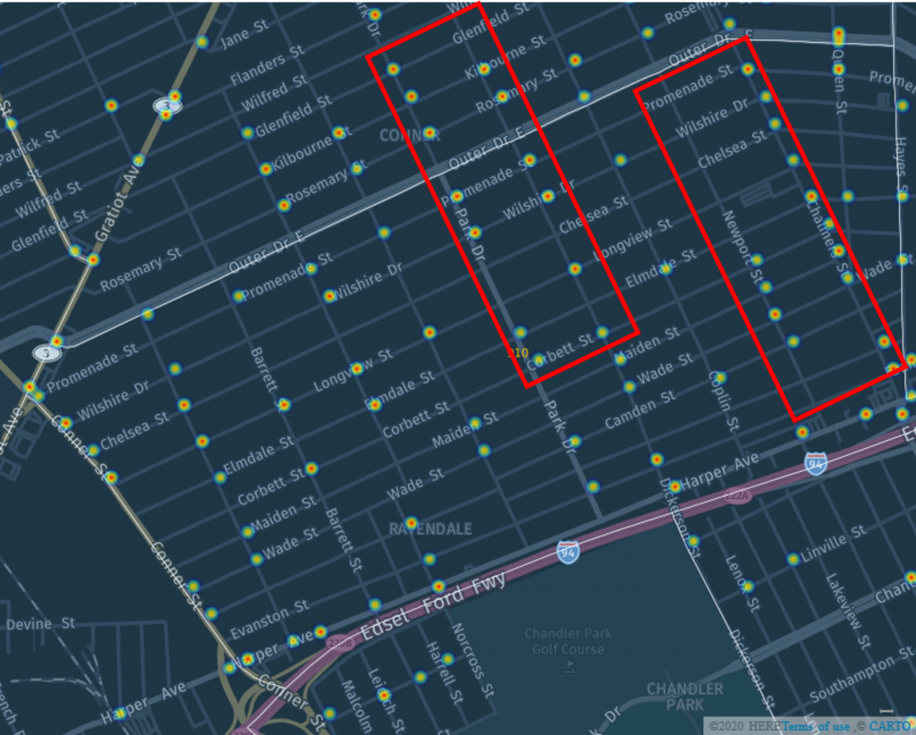
The 910 area (stretching across Outer Drive into the 909) has a couple areas with especially high assault levels – along Park Drive and Dickerson, crossing over into the 909. The other hotspot appears to be primarily on Chalmers, with some activity a block away on Newport Street.
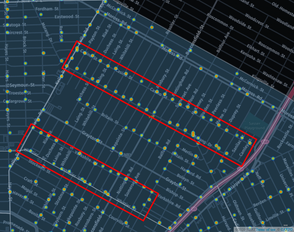
While the 901 & 910 areas certainly index high for aggravated assault, they barely compete with our familiar 907 area. Here we see two primary hotspot areas, although there is plenty of activity around them as well. Once again, Casino Street is a real trouble spot, with the parallel Morang Street showing a similar level of assaults. These blocks may qualify as the most dangerous in the city, based on what we have seen in this analysis. Further southwest in the 907, we have Yorkshire and Whittier, each showing assault levels not far behind Casino Street. In the middle sits Britain Street, with it’s own high frequency of assaults. The 907 was clearly the most dangerous part of the city in 2019, at least from an aggravated assault perspective.
That’s it for now. We’ll be following up with some more positive visuals on life in the city, so stay tuned, and thanks for reading!