Zoning restrictions can have major implications in the way a city is structured, as well as affecting how it might grow in the future. At its best, zoning can provide an orderly, consistent, organized set of rules that provide a city with the necessary tools to be both productive (i.e.- inclusion of industry and business zones) and livable (i.e.- keeping residential areas isolated from heavy industry). At its worst, the city becomes an unhealthy mix of incompatible elements, and potentially hinders future growth due to an outdated zoning plan. In this ongoing series, we’ll use data from Detroit’s Open Data Portal to understand how zoning regulations have affected the D for better and worse.
To kick off the series, I’ll take a high level overview look at how the city is currently zoned, using a variety of charts and maps to shed light on the existing situation. This will allow us to have a solid understanding of the status quo before moving on to any sort of in-depth analysis or recommendations. Future posts in the series will examine specific areas in the city to see what works and what doesn’t, what should continue, and what may need to change moving forward. In a city the size of Detroit (139 square miles), this is not a simple set of tasks, as there will be a lot of positive outcomes, as well as plenty of negative situations.
Once again I’ll turn to two of my favorite tools for visual analysis – Exploratory, where we can extend the base data using calculations, filters, and charts, and Carto, which will again help us create revealing maps. By the end of this post, the goal is to have a solid understanding for what the city’s current zoning looks like; this will then set the table for more in-depth analysis in subsequent posts.
Let’s begin with some definitions to help us understand the data. In a nutshell, we have three large categories with multiple sub-categories. Residential, business, and industrial are the three most obvious parent categories, but there are many others that populate the city. We’ll begin with these three before moving on to the less obvious categories. Let’s start with residential definitions:
| Category | Definition |
|---|---|
| R1 | Single-Family Residential District |
| R2 | Two-Family Residential District |
| R3 | Low Density Residential District |
| R4 | Thoroughfare Residential District |
| R5 | Medium Density Residential District |
| R6 | High Density Residential District |
As you can see in the adjoining table, Detroit has six distinct residential zoning categories, ranging from the traditional single family district up through high density residential districts.
For a point of reference, R1 applies to neighborhoods such as Indian Village, Boston-Edison, and many neighborhoods on the west side. R2 is a slightly less restrictive category that allows for duplexes, two-story flats, and similar. R3 areas might include houses that have been divided into multiple apartments, while R4 is a rarely used definition we’ll see more on later.
R5 and R6 cover the higher density housing that is less common in Detroit relative to many other older cities. R5 covers smaller apartment buildings that dot the city, while R6 refers to the high rise structures mainly found downtown and along the Detroit River along East Jefferson.
Business zones are also a major component of the zoning structure, and fall into several sub-categories as well. These run from B1 through B6, depending largely on where the districts are located within the city. As an example, downtown is treated quite differently than neighborhood business districts, and Eastern Market is in a different category as well. The next table has definitions for each of the business sub-categories.
| Category | Definition |
|---|---|
| B1 | Restricted Business District |
| B2 | Local Business and Residential District |
| B3 | Shopping District |
| B4 | General Business District |
| B5 | Major Business District |
| B6 | General Services District |
Next up are the industrial zones, all starting with an M (manufacturing). These also have a range of sub-categories; a designation like M4 indicates a district that is purely industrial, while others are more likely to be integrated with other types of zoning designations.
| Category | Definition |
|---|---|
| M1 | Limited Industrial District |
| M2 | Restricted Industrial District |
| M3 | General Industrial District |
| M4 | Intensive Industrial District |
| M5 | Special Industrial District |
Finally, we come to other zoning districts that are comprised of a variety of areas, none of which fit the three categories just examined. These can range from city parks through areas set aside for planned development, with a few others that are very specific in their purpose.
| Category | Definition |
|---|---|
| SD1 | Special Development District, Small-Scale Mixed-Use |
| SD2 | Special Development District, Mixed-Use |
| PR | Parks and Recreation |
| SD4 | Special Development District, Riverfront Mixed-Use |
| PD | Planned Development District |
| P1 | Open Parking District |
| SD5 | Special Development District, Casinos |
| PC | Public Center District |
There are a handful of others we won’t highlight here; suffice to say that just about any type of land or building use is addressed by one of these districts. If it isn’t, new ones can be added by the city government; note how casinos have their own designation.
Let’s run some quick visual diagnostics using Exploratory. These charts will help us understand both the frequency of individual zoning types, as well as their share of the total, measured both in districts as well as land mass.
Our first chart takes a look at aggregate splits, where we have grouped the sub-zones into higher level categories:
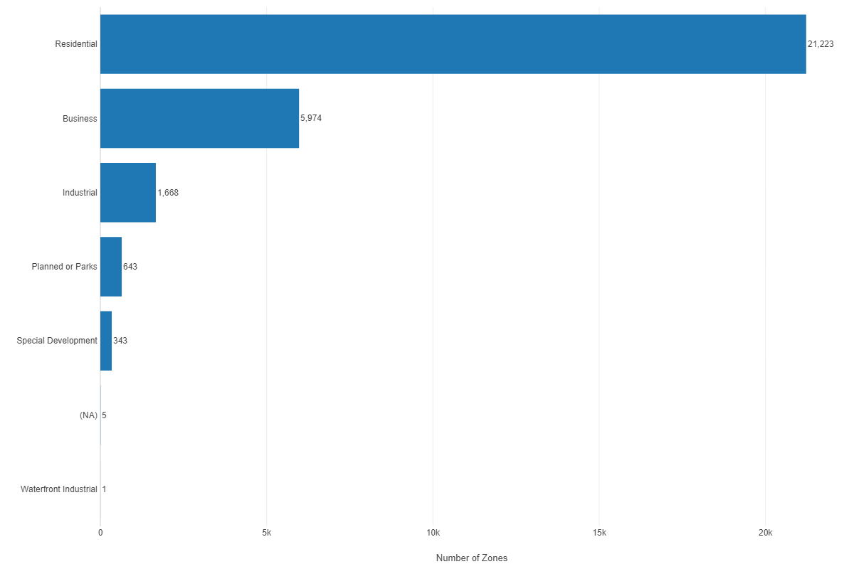
Clearly, residential zones are by far the largest component of all districts in the city. No surprise here, especially given Detroit’s history of building single- and multiple-family housing stock. We’ll see just how prevalent these residential dwellings are when we view some maps of the city in a moment. We can break out these same numbers by area; residential is even more dominant by this measure, accounting for 68% of all the square mileage in the city.
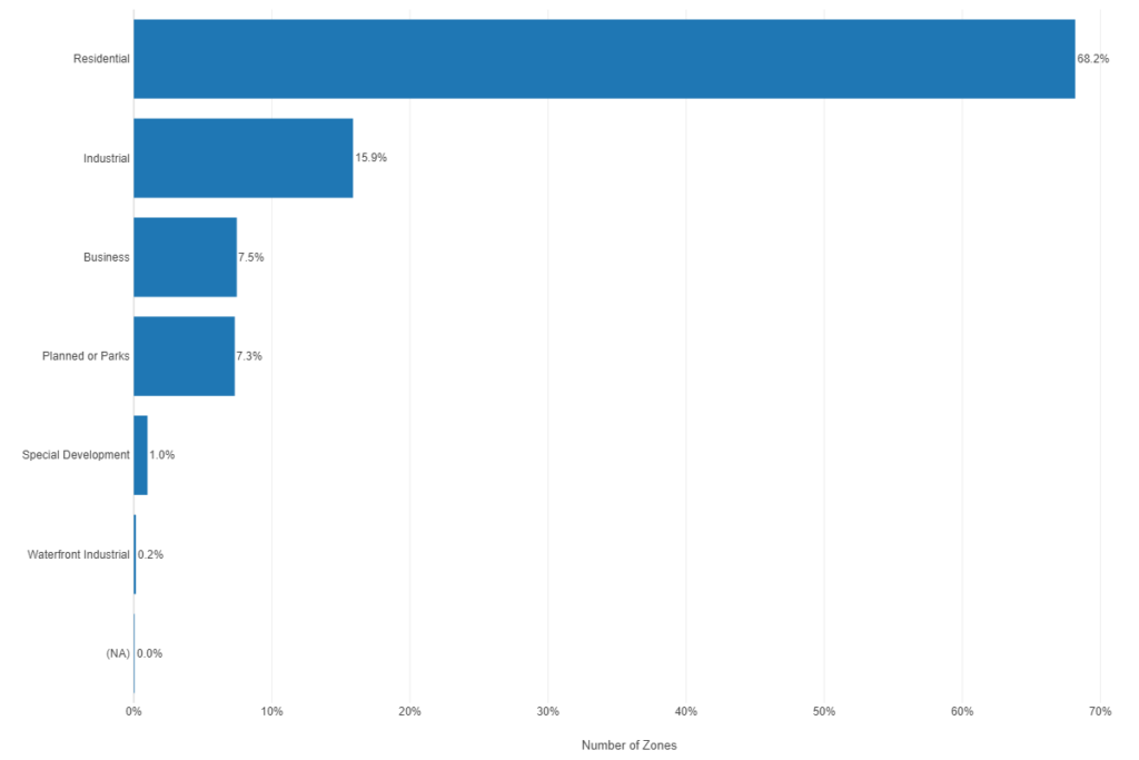
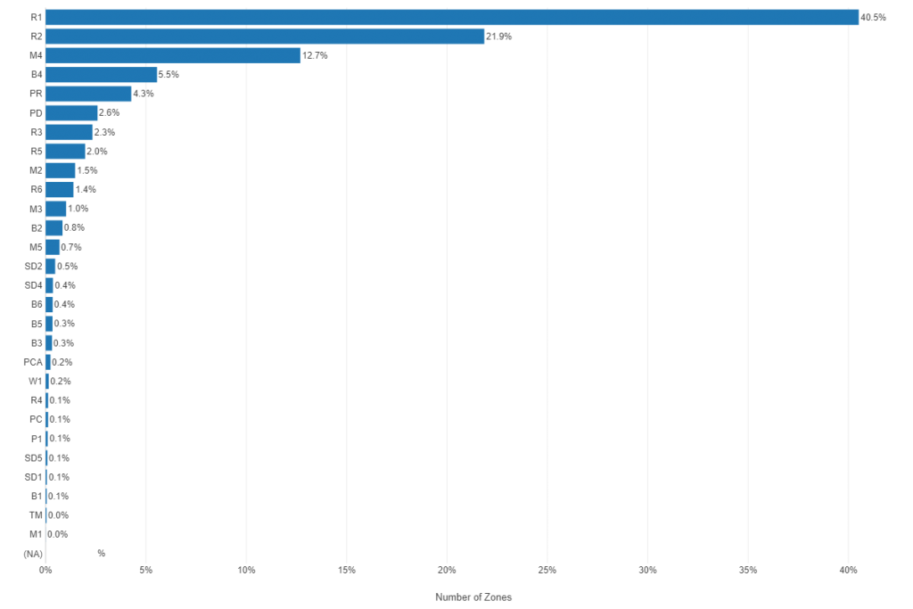
If we drill down to the specific zoning code, we can see the influence of both the R1 and R2 residential districts; together, they account for more than 62% of the city’s land area.
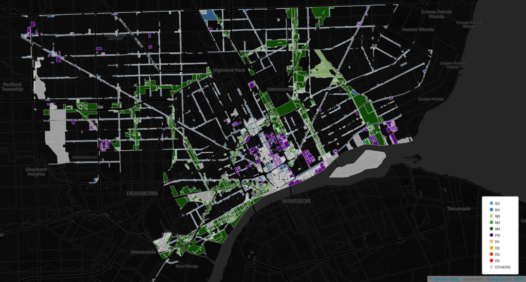
Now that we have run the basic chart analysis to get an understanding of the data, it’s time to share some maps; these will be especially useful for residents and frequent visitors to the city who have a general understanding of Detroit’s quirky boundaries. We’ll start with an overview map showing the most commonly encountered types of zoning districts.
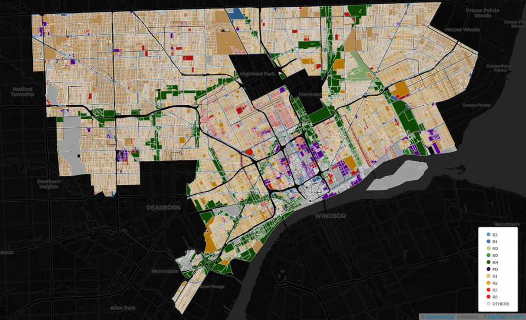
As you can see, the map has a surplus of orange-toned areas; these represent much of the city’s residential housing, especially the R1 and R2 low density forms Detroit is known for (as opposed to the greater proportion of mid- and high-density housing in other older cities). We can also see many dark green areas, typically laid out in narrow ribbons. These areas represent the M4 zones, aka Intensive Industrial Districts. One of Detroit’s challenges is how to manage the areas where these two zoning types abut one another; residents are far less willing to locate near industrial zones in the 21st century due to concerns about noise, air quality, and traffic levels.
We can also see a number of purple zones scattered around the downtown, midtown, and outlying areas of the city. These are PD zones, for Planned Development, areas where the city can work with developers in a very intentional manner to create new housing or business developments. A similar concept comes in the SD categories, with SD referring to Special Development. These will often be mixed-use developments, combining new apartments or condominiums with small retail attached or adjacent to the residential units.
We’ll finish this post with an interesting map – what would Detroit look like with no traditional residential zones? Here’s the somewhat dystopian view of a city with few places to live, a sort of zombie paradise:
And on that happy note, we’ll see you next time! Thanks for reading.